*Images courtesy of United Launch Alliance and NASA/NOAA
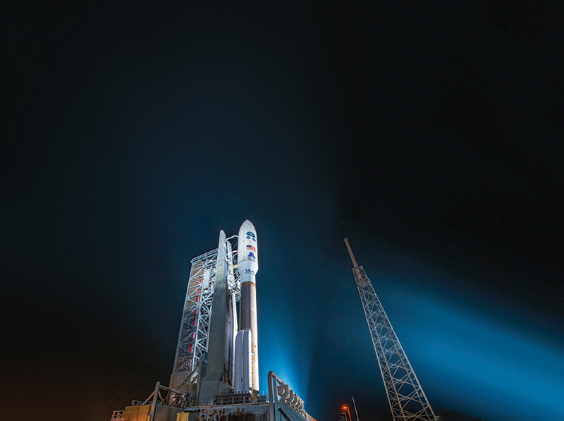
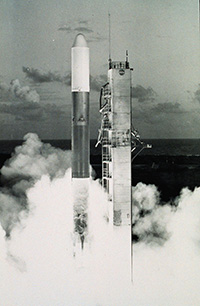
It was T-minus one month until GOES-R — America’s newest, next-generation weather satellite — was set to launch aboard an Atlas V rocket from the Cape Canaveral Air Force Station in Florida.
Nearly a dozen Drexel alumni, all of whom had worked on various stages of the decade-long project, watched anxiously as Hurricane Matthew barreled through the Caribbean on a collision course with the panhandle. When orders came to evacuate the area, the launch team worked quickly to erect a protective enclosure around the spacecraft that was scheduled to bring the multi-billion dollar project into orbit in only a few weeks.
“The running joke was that the weather satellite could be delayed by extreme weather,” says William Nilsson ’91, a mechanical systems and launch services integration engineer at Lockheed Martin, the private aerospace company contracted by NASA and the National Oceanic and Atmospheric Administration (NOAA) to build the spacecraft. “Ironically, it proved an important point. Our current weather models were wrong — Hurricane Matthew veered offshore and that made all the difference.”
The satellite, now called GOES-16 since its successful launch in November, was built to improve tracking of hurricanes, tornadoes and flash floods to help prevent Americans from being caught off guard by severe weather in the future.
The satellite is the country’s 16th Geostationary Operational Environmental Satellite (GOES) and the first in a series of four next-generation satellites that represent a major leap forward in timely and accurate weather forecasts. It scans the Earth with three times more spectral channels, offers four times clearer resolution and transmits data five times faster than older models.
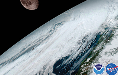
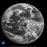
GOES-16 shot this image of the moon, which it uses for calibration.

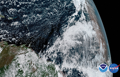
Storms and mountain waves over Argentina
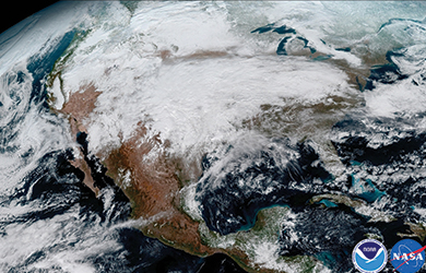
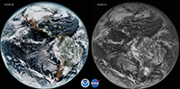
This image shows the dangerous storm system that crossed North America on Jan. 15, causing fatal freezes and ice.
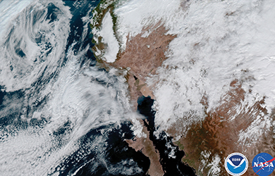
California and the Baja Peninsula.
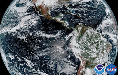
GOES-16 creates full disk images showing everything from the coast of West Africa to Guam and everything in between.
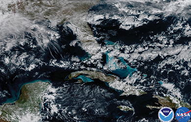
Shallow waters are evident in the Carribean and off the coast of Florida.
The Saharan dust layer, visible in the far right edge of the planet, is dry air from Africa’s coast that impacts tropical cyclone intensity and formation.
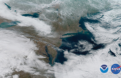
Another view of the severe January storm, as it moved across the central United States.
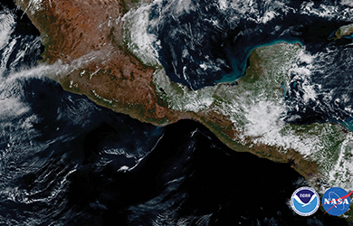
Smoke from a fire on the coast is visible over Mexico’s Yucatan Peninsula. (Images courtesy of NOAA.)
After completing a year of testing in space, GOES-16 will move into its final orbit over North America this fall.
At that point, every American will see the difference on their television screens and benefit daily from the satellite’s vigilance as they go about their lives. Images of the planet will be more detailed, storm paths will be more predictable and atmospheric data will be more accurate.
Says Nilsson: “It is like upgrading your television from black and white to high-definition.”
GOES-16 will even be able to multi-task. A specialized imaging instrument will transmit pictures of the Western Hemisphere every 15 minutes, the continental United States every five minutes, and zoom in on specific areas of storm activity as often as every 30 seconds. The GOES-16 also monitors air pollution levels, solar flares and tracks potentially hazardous space weather.
It also carries the first lightning detector flown in geostationary orbit, which tracks both in-cloud and cloud-to-ground lightning (total lightning). That’s important because increased total lightning activity can signal impending severe weather, and the real-time data collected by the satellite has the potential to improve storm warning lead times.
The GOES-16 is equipped with a transponder that can detect distress signals from airplanes, ships and even hikers and climbers, like some previous satellites. But GOES-16’s transponder is able to detect weaker beacons than its predecessors, which it can relay to a Search and Rescue Satellite-Aided Tracking, or SARSAT, ground station. Since 1982, the SARSAT system has helped to save more than 39,000 lives worldwide.
“GOES-16 is all about saving lives and property,” says Paul W. Richards ’87, spacecraft manager at NASA Goddard Space Flight Center. “The current lead-time for a tornado is only 13 minutes. With these constant updates and detailed images, we’ll have the potential to increase warning times and allow more time for people to get out of harm’s way.”
Most Americans will see what the satellite is capable of for the first time this fall, when meteorologists begin using images from GOES-16 in routine weather forecasts. But for the Drexel engineering alumni who readied the spacecraft for its debut, the satellite has been real for years. Drexel Magazine asked some of them to share what it was like to work on this dream project.
Tell the story of launch day. It sounds like it came down to the wire.
After being delayed by Hurricane Matthew, launch day finally came several weeks later. Everyone was euphoric. Since it was Thanksgiving weekend, the Federal Aviation Authority would only restrict air space for an hour. We had to move fast. I was at the operations center when the go-call began — Spacecraft-go, Atlas-go, Centaur-no-go.
Turns out, there was an issue with a valve in a similar rocket on another launch pad. But we had the same valve on our rocket. We were on the edge of our seats, our phones were exploding and thousands of people were waiting at the grandstands. With only two minutes left, they realized that no problem existed. I ran up to the roof. It was extraordinary to see the rocket rise up in the night sky. It was the perfect launch.
How did drexel prepare you for the job?
Drexel professors give students all the tools they need to succeed in the industry. For example, during our senior design project, Professor Yalcin Ertekin in the Engineering Technology Department worked closely with our team to teach us how to manage a schedule and efficiently design a manufacturing process. It was obviously on a smaller scale, but it tied directly to what I do today — my ability to perform day-to-day assembly, integration and test activities. Meanwhile, Professor Irina Ciobanescu Husanu taught us to think outside the box, solving the most complex problems in the simplest ways.
Explain how GOES-16 will save lives.
Think about the devastation of Hurricane Katrina. Ten years ago, the satellite in operation did not have enough battery power to stay running when one of the deadliest hurricanes in U.S. history made landfall. The sun was in an eclipse behind the Earth so there was no solar power. If you look closely, there is a sudden jump in the satellite images as Katrina approaches landfall.
GOES-16 closes that gap. It has enough solar and battery power to track weather every second of the day in different areas.
What was the most fun you had along the way?
Definitely mission rehearsals. We used simulators of the GOES-16 satellite to pretend it was the real launch and practice specific events that could go wrong. Next was the fun part — for me, at least. I would program in an error, such as a critical temperature or electrical failure, and the engineers would have to solve the problem. Many of these rehearsals lasted several days.
As a former astronaut, how did your space missions help you solve challenges on GOES-16?
I always joke that the hardest part of space-flight is the humans. Communication and teamwork are an astronaut’s most important tools. Between the government agencies, and the dozen or so private vendors that designed the five weather instruments, the satellite, and spacecraft, hundreds of people worked on GOES-16 at any given time. A single mistake could cause a day-for-day delay and cost millions of dollars.
Then there were the complex technical requirements. Once each part was built, it had to be integrated onto the spacecraft. None of these delicate instruments could interfere with each other and they all had to survive the environment of space. There is a saying in spacecraft testing — “shake, bake and radiate.” That means we have to vigorously test each instrument and component to ensure it can withstand the severe G-forces from the launch, hundreds of degrees of heat from the sun, the extreme cold in shade and high levels of radiation. This of course is all happening in the vacuum of space. I knew firsthand that this was not an easy task.
How did you first become involved with GOES-16?
I was a young, naïve and mildly terrified co-op student when I started at Lockheed Martin. It was my first job and they assigned me to test the root hinge assembly, which is used to deploy the solar panel on the satellite. It was what we call a “single point failure.” That means if the hinge does not work, the satellite does not get power and the mission fails. No pressure, right? I feel very spoiled that I was able to see my first project go into space years later. I imagine it feels a little like sending your first child off to college.
What was your personal contribution to the project?
My job was to ensure the satellite met the thermal design requirements. Managing heat transfer is critical, because space is very hot in the sun and very cold in shadow, yet the satellite likes near room temperatures while generating 3kW of heat — about what you need to heat a typical living room. For GOES-16, we did a 55-day thermal vacuum test — the longest one in my 30-year career. We put the satellite in a chamber to simulate the vacuum and cryogenic temperatures in space and the sun shining on the satellite in different seasons to understand how it affected our delicate instruments. I can truly say I have applied my Drexel coursework at NASA — specifically recalling when Professor Young I. Cho in the Mechanical Engineering and Mechanics Department discussed fluid modeling through an artery. I now use that knowledge in fluid flow design applications
at NASA.
How did you celebrate after the launch?
I was one of the few engineers who had to wait to crack open my celebratory beer. The Solar Wing System (SWS), which provides power to the satellite and studies the sun, was not fully deployed until 12 days after the launch. To fit the satellite in the rocket, the SWS folded up like an accordion. If any of the 16 restraint and release devices failed to release the wings, the SWS would not deploy. Our tests were successful but you never know what part could have been jarred loose during launch or frozen stuck in the cold environment of space. Thankfully, all of the time spent in the basement engineering lab at Drexel running experiments and crunching numbers paid off, and our successful test led to a successful deployment of the SWS in space. I was at home when I heard the news — I hugged my wife and opened that beer.
What comes next for GOES-16 — and for you?
[Laughs] Well, the work was not over after the launch — we still had to get GOES-16 fully operational. For the past six months, the communications team has been working at NOAA’s two state-of-the-art ground stations where a dozen 50-foot antennas communicate with the various weather instruments. So far, the images look spectacular and we expect these weather forecasts from the satellite to actually be on televisions this fall.For me, personally, I am looking ahead to retirement. GOES-16 is an experience that comes once in a lifetime. I feel like I am leaving a legacy behind that will save people’s lives and property and I am thankful Drexel prepared me for that.
50 Years of Forecasts
’60s
Since the 1960s, weather satellites have been scanning the Earth from more than 22,000 miles away. Meteorologists then interpret this data to create weather forecasts. The satellites work by detecting infrared and visible energy — such as heat and reflected sunlight — emitted from below.
’75
The first Geostationary Operational Environmental Satellite (GOES) launches. The early GOES (A–C) were spin-stabilized, viewing Earth only about 10 percent of the time and providing data in only two dimensions. There was no indication of cloud thickness, moisture content, or temperature variation with altitude.
’80s
Weather satellites could now obtain vertical profiles of temperature and moisture throughout the atmosphere. This allowed forecasters to monitor rapidly changing events, and to predict fog, frost and freeze, dust storms, flash floods, and even the likelihood of tornadoes.
’94
GOES-I brought real improvement in the resolution, quantity and continuity of the data. Advances in two technologies were responsible: three-axis stabilization of the spacecraft and separate optics for imaging and sounding. The satellites could suspend their routine scans to concentrate on a small area of quickly evolving events.
’06-’10
GOES-N, O and P further improved the imager and sounder resolution and used geographic landmarks and stars to better pinpoint intense storms. Detector optics were improved and imaging became continuous.
’16
The GOES-R series (GOES-R, S, T and U) marks the first major technological advances since 1994. Their imagers allow for the “nowcasting” of severe storms across the continental United States.